presentation of the water management in the City of Zagreb, several facts from a part concerning water resources on a national level stated in the Republic of Croatia's Strategy „Croatia in the 21st Century“ document should be mentioned. Croatia is in one of the groups of relatively water-rich countries where issues with water and around water have not yet been problematic and water resources are not yet a limiting factor of development. According to studies by UNESCO in 2003, Croatia has the availability and abundance of water resources at a very high fifth place in Europe, and 42nd in the world. The balance of surface and groundwater show that Croatia has a large unevenly spatially and temporally distributed quantities of surface and groundwater. Accordingly, the institutions

responsible for water management have the authority, commitment and ability to design quality and adapt solutions viable for all parts of the water system and all water activities along with on water-dependent economy. The priority task of water management is the fabrication of planning documents at all levels of management and water management. In addition, the fundamental attitudes and policies of Croatian development, along with the place and role of water in society established on the Constitution and laws are respected, from which it follows:
- water is a public resource that has special protection under the Republic of Croatia and cannot be anybody's property;
- water is the means for living and working and exploited by legally established conditions;
- total water wealth in Croatia is a valuable natural and developmental resource and shall be managed rationally and sustainably;
- total water demand and regulated water regime should be evenly and fairly fulfilled to meet the needs of the entire national territory;
- priorities and criteria in water management should be determined at a national level, starting from the obligation of integrated environmental protection and achieving the public, economic and sustainable development, in line with the development policy of the country.
The issue of water management in the City of Zagreb can be seen in two aspects – water as a natural flood threat and water through management as a natural resource essential for everyday life. These two aspects will be described below as two separate chapters.
Flood threat to the City of Zagreb
Through its natural flow through the City of Zagreb, the Sava river has always been a latent threat to the flooding of its surrounding area. In 1895. there were two major floods that flooded not only the areas along the Sava river but also the Lower Town streets. After several major floods causing large damage from the middle till the end of the 19th century, in 1899 a decision was made on the beginning of the Sava river regulation at the City of Zagreb. Most of the work on the bed of the river Sava was performed at the beginning of the 20th century until World War I temporarily stopped the work (at that time, Sava near Zagreb area already started forming its current shape). During the interwar period, the work on the basin and the lifting of the embankment along the two sides of the river continued. The regulation was carried out 145 NATIONAL SECURITY AND THE FUTURE 1-2 (18) 2017 by the most up-to-date technique at that time (Wolfsche- Gehängebau), which was successfully applied by the Croatian experts on the basin of Sava river after an engineer named August Wolf applied it for the regulation of river Isar. As the stream of the Sava river near Zagreb is cut into gravelly pebbled layers, which, by constant rotation of the large impurities, causes frequent migrations of the cedar and thus creates specific geological conditions, the old sleeves should be covered within the regulation. (Slukan Altić, 2010). Since the end of the World War II, the regulation that had been implemented had succeeded in stimulating the intensive urbanization of parts of the area between the river Sava and the railway line, and it was a solution for safe further expansion (although there was an outbreak of hinterland flooding), until the catastrophic flood in 1964.The reason for this largest flood in the Zagreb area that happened on the night of 25th to 26th October, was the cracking of the existing embankment. Sava river flooded one third of Zagreb area, and the water covered more than 6,000 hectares of narrow urban area, where more than 180,000 people lived. Flood levels are shown in Figure 1 showing the area of the Savska road axis.
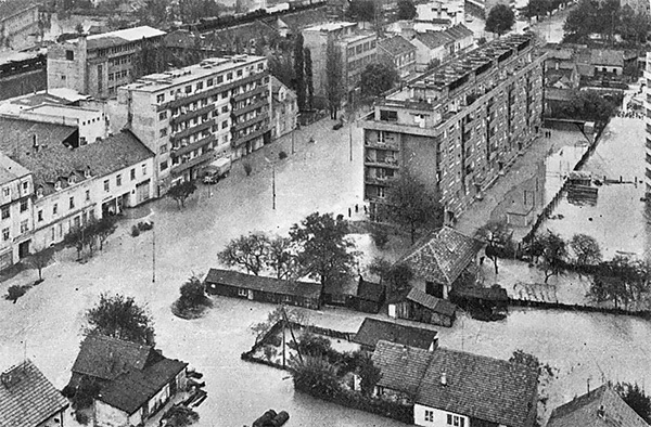
Figure 1. The flooded area of the city center on the axis of Savska road (author: Šime Radović)
The measured water level of the Sava river at that time was 514 centimeters. The consequences after the withdrawal of the river had dramatic losses: 17 lost human lives, 65 injured (10 000 people were temporarily moved from their homes to schools, centers and other public buildings or stayed with relatives and friends). Due to such a large number of casualties, the city authorities have decided to build new settlements in locations in Dubrava, Volovčica, Gajnice and Botinec. Although most of this housing stock consisting of semi-mounted and mounted flats was foreseen as a temporary solution for the disposal of the population who remained homeless, for some, this solution became permanent. The situation after this flood led to the activities of designing new and reconstruction of the existing Sava embankments in Zagreb, Sisak and Karlovac, as well as the construction of the Sava - Odra - Sava seaplane channel, which provided the City of Zagreb with a high degree of safety even when it comes to highest water levels of the Sava river (Slukan Altić, 2014). Today, the defensive embankments along the river Sava through the town area have been carried out from Podsused bridge to Mičevački bridge at a distance of 300 meters. The basin is regulated for small and medium water in the width of 100 meters (Figure 2).
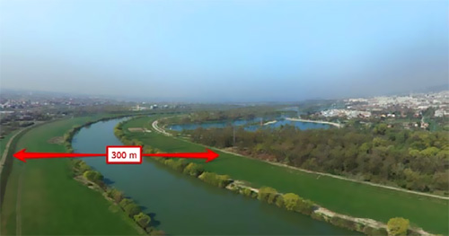
Figure 2. Defensive embankments along the river Sava through the urban area
Looking back over the past ten years, due to climate change a constant danger of extreme rainfall is present, resulting in high water levels. The last major threat to Zagreb and its surroundings was in September 2010 (the cause of the flood were massive rains in Slovenia, which have not been recorded in the past 100 years, leading to a rapid increase in the Sava River flow). The embankment system in the Zagreb area withstood the water wave but the surrounding areas (Velika Gorica, Zaprešić, Samobor) were affected to a large extent. Only the City of Zagreb is protected against big waters of the river Sava, which, according to estimates, is safe from 1000-year large waters. Other areas along the Sava river are mostly insufficiently protected.
Upstream from Zagreb to the Slovenian border the defensive embankments were only partially built, so the lower lying parts of several settlements of the wider Zaprešić and Samobor regions were often flooded. Downstream from Zagreb to the Serbia border, many areas along the river Sava have a lower level of security than required because the Middle Posavlje protection system is unfinished and existing defensive dams are insufficiently high in many places.
Figure 3 shows an interactive map made by Croatian Waters, which shows the likelihood of flooding in the City of Zagreb and the surrounding area (dark blue surfaces show high probability, and surfaces marked in light blue shades show medium and low probability of flooding).
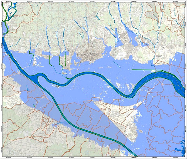
Figure 3. Interactive map showing the likelihood of flooding in the area of the City of Zagreb and its surroundings (source: Croatian Waters, http://voda.giscloud.com/map/321490/karta-opasnosti-od- poplava-po-vjerojatnosti-poplavljivanja)
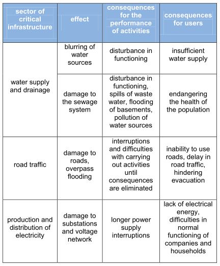
Table 1 shows possible impacts of flooding on certain critical infrastructure sectors (Službeni glasnik, 2016.):
City of Zagreb providing assistance after the Gunja flood
In addition to flood protection activities within the boundaries of its administrative area, the City of Zagreb has been involved in assisting neighboring settlements. One such example was aiding the area affected by the great flood in Vukovar-Srijem County in 2014. At that time most affected municipalities were Gunja, Drenovci and Vrbanja. The 67- kilometer long threat caused by the largest water wave in a thousand-year average of 1194 centimeters was expanded in a very short period of time. Part of the flooded area is shown in Figure 4.
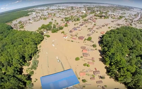
Figure 4. Part of the flooded area in Vukovar-Srijem County
With the timely engagement of county, city (Županja) and municipal protection and rescue units and civilian protection commands, along with the Croatian Army, police, operational forces, volunteers and many other institutions and citizens, it was managed to protect the most critical points on the embankment (Vukovar-Srijem County, 2014.). Unfortunately, two human lives were lost in the floods with great material damage (some direct and indirect damage indicators, complete damage was measured in billions of kunas). The lucky circumstance was that there was no transmission of infectious diseases, and no cases of property crimes or events that would have affected the deterioration of the security situation (DUZS, 2014).
After the flood, the City of Zagreb reacted immediately and engaged in raising funds for people who had been affected. On several occasions, assistance was provided in the form of household appliances, materials for the reconstruction of the interior of the houses along with drainage appliances in the Posavina county, and among other things, free textbooks were provided for pupils and students of elementary and high schools in the affected area (City of Zagreb, 2014).
Management of the water supply system as a natural resource essential to everyday life
The basic concept of the water supply system is the forcible raising of water from the underground waters of the Sava alluvium into cisterns, with the distribution of water to the consumers. At this moment, there are eight waterbeds in Zagreb and the surrounding area with a total of 30 wells with a total supply capacity of 5,250 liters of water per second, which is sufficient for today's consumption for now, which means that the City also has supplies of drinking water, ie surpluses in comparison to its needs. Such stocks are extremely sensitive to pollution, so apart from purification itself, a constant quality control of water is carried out by authorized laboratories of competent institutions, and since the 1990s systematic monitoring of groundwater quality in the flow areas of waterworks has been carried out.
The sewerage system of the City consists of about 1,818 km of canal network of all profiles and 54,500 street drains and over 69,017 connections connected to 750,000 inhabitants as well as economic facilities, public facilities and the traffic area. According to the drainage method, the City of Zagreb uses a mixed type of sewage system, which indicates the acceptance of all waste water (fecal, industrial, surface, etc.). The exceptions are the smaller parts of the area beneath Sljeme. Existing sewage systems drain sewage and rainwater from the urban area which goes directly to the river Sava and partly indirectly via the Črnec stream. The development of economic activities and the urbanization of the City of Zagreb and surrounding areas results in an increase of water needs, while on the other hand discharge of waste water increases the pollution of surface and groundwater and thus damages the existing unfavorable ecological situation.
Precautionary and recovery measures of such situations are solved by the complex implementation of a separate drainage and purification system for waste sanitary-fecal and technological waters.
In the area of the City of Zagreb, a separate sewage drainage system has been adopted, which means that waste sanitary and technical waters are drained and cleaned by a separate system and the waste rainwater is drained to the receiver by a separate system. The system for drainage and purification of waste sanitary and technological waters of the City of Zagreb consists of:
- collectors (gravity and pressure)
- pumping stations
- sewerage primary networks
- sewerage secondary networks (connections)
- devices for purification of waste sanitary- technological waters
Wastewater collectors drain wastewater from individual sub- basins to the purifier. The pumping stations are interpolated on gravity and pressure collectors (Službeni glasnik, 2016). Since the City of Zagreb is in the seismic area, it should be taken into account that an earthquake could affect supply and drainage. The consequences that may occur in case of an earthquake are presented in Table 2.
Table 2. Possible effects of an earthquake on water supply and drainage system
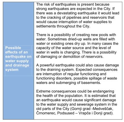
Possible effects of an earthquake on water supply and drainage system
- The risk of earthquakes is present because strong earthquakes are expected in the City. If there was a devastating earthquake it would lead to the cracking of pipelines and reservoirs that would cause interruption of water supplies to settlements throughout the City.
- There is a possibility of creating new pools with water. Sometimes dried-up wells are filled with water or existing ones dry up. In many cases the capacity of the water source and the level of water in wells is changing. There is a possibility of damaging or demolition of reservoirs.
- A powerful earthquake could also cause damage to the draining system. Expected consequences are interruption of regular functioning and functioning disorders, possible spillage of waste waters and submerging of basements.
- Extreme consequences could be endangering the health of the population. It is estimated that an earthquake would cause significant damage to the water supply and sewerage system in the old parts of the City (Gornji grad -Medveščak, Črnomerec, Podsused – Vrapče i Donji grad).
Conclusion
Current estimates of damages after floods throughout the world, including in Croatia, have shown that they were always much higher than the cost of implementing preventive measures. One of the many testimonies of this fact was the successful evacuation of the great water wave at river Sava in 1990 that had worse hydrological features than the 1964 flood, which due to the insufficient development of the protective system at the time caused catastrophic flooding in Zagreb.
Today's environmental protection from uncontrolled spreading of contamination of known and unknown origin through flood waters adds an additional dimension to the issue of flood protection. Therefore, such experiences require constant caution and constant care of the state of the protective systems. In Croatia, all ministries involved in the issue of asanation declared that this is not in their jurisdiction.
References
- Hrvatski sabor (2003.), Strategija upravljanja vodama (Narodne novine no. 91/08), URL: NARODNE NOVINE (PDF) (27.05.2017.)
- Slukan Altić, M. (2010.), Povijest regulacije rijeke Save kod Zagreba i njene posljedice na izgradnju grada (Hrvatske
- vode no.18 (2010) 73 205-212), URL: VODA.HR (PDF) (28.05.2017.)
- Slukan Altić, M. (2014.), Velika poplava u Zagrebu 1964.
- (Hrvatska vodoprivreda no. 207 (2014) 88-93), URL: VODA.HR (PDF) (28.05.2017.)
- Vukovarsko-srijemska županija (2014.), Izvješće o katastrofi na području Vukovarsko-srijemske županije, URL: VUSZ.HR (PDF)
- DUZS (2014.), Poplave u Vukovarsko-srijemskoj županiji u svibnju 2014., URL: DUSZ.HR (PDF)
- (31.05.2017.)
- Grad Zagreb (2014.), Službena Internet stranica Grada Zagreba, Zagreb nastavlja pomagati Gunji, URL: http://zagreb.hr/zagreb-nastavlja-pomagati-gunji/88650 (01.06.2017.)
- Službeni Glasnik (2016.), Procjena ugroženosti stanovništva, materijalnih i kulturnih dobara i okoliša od katastrofa i velikih nesreća za područja Grada Zagreba
- (Službeni glasnik no.4 from 21. March 2016.), URL: ZAGREB.HR (PDF) (29.05.2017)
- Hrvatske vode (2014.), Interaktivna karta opasnosti od poplavljivanja, URL:http://voda.giscloud.com/map/321490/karta-opasnosti-od-poplava-po-vjerojatnosti-poplavljivanja (28.05.2017.)
1 Affiliation: City of Zagreb - Emergency Management Office, Kneza Branimira 71b, 10000 Zagreb
E-mails: pavle.kalinic@zagreb.hr, anastazija.bakran@zagreb.hr, boris.guberina@zagreb.hr.
Kalinić, A. Bakran, B. Guberina: WATER MANAGEMENT IN THE CITY OF ZAGREB